 |
 |
 |
 |
 |
- Welcome
- Search TravelJharkhand.com
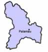 The district of Palamu lies between 23°50' and 24°8' north latitude and between 83°55' and 84°30' east longitude. The district covers an area of 5043.8 km² and has a population of 1,533,176. It is bordered on the north by Son and Bihar rivers, on the east by the Chatra and Hazaribagh districts, on the south by Latehar District and on the west by Garhwa District. A great proportion of Palamu consists of hills covered with jungle. The soil in many parts is strongly impregnated with iron. Palamu is well known for rich mineral resources.
Daltonganj, situated on the North Koel river, 24 degree 3’ north, and 84 degree 4’ east, is the district headquarters of Palamu. Daltonganj is named after Colonel Dalton, Commissioner of Chhota Nagpur in 1861. The distance between Daltonganj and Ranchi is about 165 Km.
The Origin of the name Palamu is a matter of different opinions. According to some, it is derived from the Hindi word palana means “a place of refuse”. Another suggestions is that the name is combination of Pala meaning “ forst” and mu means “dead “, making it "dead due to frost". It may be due to the extreme winter temperatures.
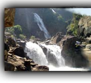
The Palamu district is home to the famous 'Palamau National Park' known for its wild life. The park is spread over a core area of 250 square kilometers. The area is rich in flora and fauna but also prone to severe droughts. The Palamau National Park was brought under Project Tiger in the year 1973 and is among the original tiger reserves of India. Sal and bamboo are the main vegetation. The tourists can drive through dense patches of sal and bamboo in the park. The wildlife sanctuary can be reached by train from Daltonganj (25km) or by air from Ranchi (180km).
Palamu fort is also an important spot tourists must see. Most interesting of all is the massive and beautifully carved stone gate. In the new fort the 'Nagpuri gate' is of great beauty. It is said to have been imported of great expense by Medni Roy, the greatest of the Rajas of "Palamau", after he had sacked the place of the Maharaja of Chhotanagpur. The Auranga river flows close by. There are high hills and dense jungles all around.
The principals rivers flowing through Palamu district are Koel and its tributaries, the Auranga and the Amanat. The climate of Palamu varies can be divided in to three main seasons. The cold seasons from November to March, the hot season from March to May and the monsoon season from June to September. Temperature varies from 47 degree to 38 degree C during the summer month while in the monsoon months it is only 6 degree C to 8 degree C.
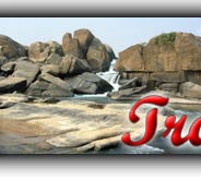
Blocks in Palamu District are Bishrampur, Chainpur, Chatarpur, Daltanganj, Hariharganj, Hussainabad, Lesliganj, Manatu, Pandu, Panki, Patan, Satbarwa and Haidernagar. The major tourist destinations include Palamu Tiger Reserve, Amjharia, Betla Forest, Daltonganj, Dundu, Gulgulpat, Kanti Falls, Kechki, Kulka, Loda Falls, Palamau Fort etc..
Read more >> History of Palamu
Read more >> Palamu - At a Glance
 The movement for a separate state of Jharkhand is an odyssey spread over a century which is traced back to the early 1900s, when Jaipal Singh, an Indian Hockey captain and Olympian, suggested the idea of a separate state consisting of the southern districts of Bihar. The idea did not become a reality, however, until August 2, 2000, when the Parliament of India passed the Bihar Reorganization Bill to create the state of Jharkhand, carving 18 districts .......
 Jharkhand has a population of 26.90 million, consisting of 13.86 million males and 13.04 million females. Like most of our states Jharkhand is also a melting pot where people from different parts of the country have come and settled down. The population consists of 28% tribes, 12% Scheduled Castes and 60% others. There are 32 different tribal communities, major one being Santhals, Oraons, Mundas and Hos. Other tribes include Asur, Baiga, Banjara, Bathudi, Bedia, Binjhia, ......
Jharkhand's culture is rich and diverse and as a result unique in its very own way. Archeaologists have unearthed pre-Harappan pottery, pre-historic cave paintings and rock-art from various parts of Jharkhand. That hint at ancient, cultured civilizations inhabiting these parts. The intricate woodwork, the pitkar paintings, tribal ornaments, stone carvings, dolls and figurines, masks and baskets, all are pointing towards the cultural wealth of Jharkhand existed even before the ........
Various religious fairs and festivals celebrated in Jharkhand. Barura Sharif, Belgada Mela Simaria, Bhadli Mela Itkhori, Chatra Mela, Kolhaiya Mela Chatra, Kolhua Mela Hunterganj, Kunda Mela Pratappur, Kundri Mela Chatra, Lawalong Mela, Rabda Sharif, Sangat and Tutilawa Mela Simaria are some of the prominent fairs and festivals of Jharkhand. Specific festivals of the tribes are Karma, Manda, Sarhul, Jani shikar, Bandna etc. Sarhul is the spring festival where Sal tree .......
Jharkhand's culture is rich and diverse and as a result unique in its very own way. Archeaologists have unearthed pre-Harappan pottery, pre-historic cave paintings and rock-art from various parts of Jharkhand. That hint at ancient, cultured civilizations inhabiting these parts. The intricate woodwork, the pitkar paintings, tribal ornaments, stone carvings, dolls and figurines, masks and baskets, all are pointing towards the cultural wealth of Jharkhand existed even before the ........
Jharkhand's culture is rich and diverse and as a result unique in its very own way. Archeaologists have unearthed pre-Harappan pottery, pre-historic cave paintings and rock-art from various parts of Jharkhand. That hint at ancient, cultured civilizations inhabiting these parts. The intricate woodwork, the pitkar paintings, tribal ornaments, stone carvings, dolls and figurines, masks and baskets, all are pointing towards the cultural wealth of Jharkhand existed even before the ........
Jharkhand has a population of 26.90 million, consisting of 13.86 million males and 13.04 million females. Like most of our states Jharkhand is also a melting pot where people from different parts of the country have come and settled down. The population consists of 28% tribes, 12% Scheduled Castes and 60% others. There are 32 different tribal communities, major one being Santhals, Oraons, Mundas and Hos. Other tribes include Asur, Baiga, Banjara, Bathudi, Bedia, Binjhia, ......
Jharkhand's culture is rich and diverse and as a result unique in its very own way. Archeaologists have unearthed pre-Harappan pottery, pre-historic cave paintings and rock-art from various parts of Jharkhand. That hint at ancient, cultured civilizations inhabiting these parts. The intricate woodwork, the pitkar paintings, tribal ornaments, stone carvings, dolls and figurines, masks and baskets, all are pointing towards the cultural wealth of Jharkhand existed even before the ........
Various religious fairs and festivals celebrated in Jharkhand. Barura Sharif, Belgada Mela Simaria, Bhadli Mela Itkhori, Chatra Mela, Kolhaiya Mela Chatra, Kolhua Mela Hunterganj, Kunda Mela Pratappur, Kundri Mela Chatra, Lawalong Mela, Rabda Sharif, Sangat and Tutilawa Mela Simaria are some of the prominent fairs and festivals of Jharkhand. Specific festivals of the tribes are Karma, Manda, Sarhul, Jani shikar, Bandna etc. Sarhul is the spring festival where Sal tree .......
Jharkhand's culture is rich and diverse and as a result unique in its very own way. Archeaologists have unearthed pre-Harappan pottery, pre-historic cave paintings and rock-art from various parts of Jharkhand. That hint at ancient, cultured civilizations inhabiting these parts. The intricate woodwork, the pitkar paintings, tribal ornaments, stone carvings, dolls and figurines, masks and baskets, all are pointing towards the cultural wealth of Jharkhand existed even before the ........
Jharkhand's culture is rich and diverse and as a result unique in its very own way. Archeaologists have unearthed pre-Harappan pottery, pre-historic cave paintings and rock-art from various parts of Jharkhand. That hint at ancient, cultured civilizations inhabiting these parts. The intricate woodwork, the pitkar paintings, tribal ornaments, stone carvings, dolls and figurines, masks and baskets, all are pointing towards the cultural wealth of Jharkhand existed even before the ........Home Must see spots Hotels Travel Agencies Advertise with us Contact Feed Back COPYRIGHT © 2008 TravelJharkhand.com | | Designed and Developed by GIGISOFT Solutions |