 |
 |
 |
 |
 |
- Welcome
- Search TravelJharkhand.com
 Gumla district in Jharkhand state is well known for its natural beauty and hill resorts. Gumla area was under Lohadaga province during british rule. In 1843 it was brought under bishunpur province that was further named Ranchi. Actually Ranchi district came into existence in 1899. The territory occupied by the current Gumla district became a sub-division of Ranchi district in 1902. This district was formed on 18 May 1984 by separating the Gumla sub-division from the restwhile Ranchi district, which was then in Bihar state. Sri Jagannath Mishra, then ruling chief minister of Bihar inaugurated the new district and Sri Dwarika Nath Sinha became the 1st deputy commissioner. Till 30th April 2001, Gumla district consisted on two sub-divisions namely Gumla and Simdega. But after the creation of Jharkhand State , a new district of Simdega was carved out of Gumla district on 30th April 2001.
For a very long time, Gumla was a meeting center for people from the Jharkhand who flocked here to exchange goods using the barter system, and the place was called Gaw-Mela. The name 'Gumla' is believed to derived from two Hindi words namely, Gaw means cows and Mela meaning fair. The place became known as Gaw-mela, and then the word transformed itself into Gumla. Another legend says that word 'Gumla' derived from Mundari language, which relates to the occupation of the local Tribes in rice processing work (dhan-kutna).
Chhotanagpur region was ruled by Kings of Naga dynasty during the medieval period . Baraik Devenandan Singh was the ruler of now existing Gumla region at that time. During the Kolh Rebel of 1931-32, Vakrat Say, a prominent leader in the Gumla region played a prominent role. Ganga Maharaj, who built the famous Kali temple at Sri Ramnagar, also played an active role in Quit India Movement of 1942.
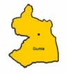
Gumla district is situvated between 22° 35' to 23° 33' north latitude and 84° 40' to 85° 1' east longitude. Gumla is situvated on southern part of the Chota Nagpur plateau which forms the eastern edge of the Deccan plateau which forms the southwestern part of the Jharkhand State.Blessed with natural beauty and mineral resources, the district of Gumla is covered by dense forests, hills and rivers. It is a matter of great regret that beinga territory of great historical importance, Gumla has not been brought under historical research map of India.
Gumla town is the administrative headquarters of Gumla District. It is also the main town in Gumla district. It is located 137 km south-west of Ranchi. Gumla is considered to be the birth place of the hindu God 'Hanuman'. A temple a few kilometers away from the city of Gumla is dedicated to him and his mother. The district also contains mountains named "Risyamook", which are mentioned in the Ramayana. Gumla had a population of 39,790. Gumla has an average literacy rate of 75%, higher than the national average of 59.5%: male literacy is 80%, and female literacy is 70%. The majority of people (about 80%) speak Oraon, but Hindi is used for communicating with non-Oraon people. Other languages spoken in this region of Jharkhand includes Nagpuri or Sadri, Oriya, and Bihari.Gumla has a rich adiwasi culture and is colourful with the shades of nature. "Chhotanagpur ki raani" Netarhat, a hill station is located in this district.
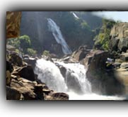
Netarhat is situated at an altitude of 3671 ft. It is located 156 km west of Ranchi town. Netarhat is covered with thick forests and is an health holiday resort. Netarhat is famous for its glorious sunrises and sunsets during the summer months. It is a plateau covered with thick forests where tourists visit to enjoy the breath taking sunrise and sunset. Netarhat has several places of tourist interests including Magnolia Point (10 km from Netarhat, ideal site for viewing sunset), Upper Ghaghri Water Fall (4 km from Netarhat), Lower Ghaghri Water Fall (10 km from Netarhat), Koel View Point (3 km from Netarhat), Lodh Falls (60 km from Netarhat, the highest waterfall in Jharkhand), Sadani Fall (35 km from Netarhat, called a "Mini Pahalgam")
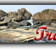
The terrain of Gumla district is highly undulating and there are existence of many rivers and streams.Major rivers flowing through Gumla district include South Koyel, North Koyel and Shankh River. There are various ributaries to these main rivers on which there are some pictorious waterfalls. The forest covers an area of 1.35 lakh hectares out of the total 5.21 lakh hectares of land in Gumla district.
Gumla district enjoys a good climate characterized by a pleasant cold and temperate weather conditions. Gumla has a sub-tropical climate. Temperature ranges from maximum 40 to 20°C during summer, and minimum 21 to 3°C during winter. The annual rainfall is about 1450 mm. From June to September the rainfall level is about 1,150 mm.
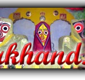
Main tourist attractions in and around Gumla includes Anjan (18 km away from Gumla), Baghmunda (famous for Ajanta caves stone idols), Rajendra, Dewaki, Hapamuni (Famous for Mahamaya temple), Palkot, Nagfeni (famous for the Jagannath temple), Tanginath, Birsa Munda Agro Park etc. The old world charm of the tribal culture remains intact in Gumla, attracting tourists from far and wide.
Read more >> Gumla district - At a Glance
 The movement for a separate state of Jharkhand is an odyssey spread over a century which is traced back to the early 1900s, when Jaipal Singh, an Indian Hockey captain and Olympian, suggested the idea of a separate state consisting of the southern districts of Bihar. The idea did not become a reality, however, until August 2, 2000, when the Parliament of India passed the Bihar Reorganization Bill to create the state of Jharkhand, carving 18 districts .......
 Jharkhand has a population of 26.90 million, consisting of 13.86 million males and 13.04 million females. Like most of our states Jharkhand is also a melting pot where people from different parts of the country have come and settled down. The population consists of 28% tribes, 12% Scheduled Castes and 60% others. There are 32 different tribal communities, major one being Santhals, Oraons, Mundas and Hos. Other tribes include Asur, Baiga, Banjara, Bathudi, Bedia, Binjhia, ......
Jharkhand's culture is rich and diverse and as a result unique in its very own way. Archeaologists have unearthed pre-Harappan pottery, pre-historic cave paintings and rock-art from various parts of Jharkhand. That hint at ancient, cultured civilizations inhabiting these parts. The intricate woodwork, the pitkar paintings, tribal ornaments, stone carvings, dolls and figurines, masks and baskets, all are pointing towards the cultural wealth of Jharkhand existed even before the ........
Various religious fairs and festivals celebrated in Jharkhand. Barura Sharif, Belgada Mela Simaria, Bhadli Mela Itkhori, Chatra Mela, Kolhaiya Mela Chatra, Kolhua Mela Hunterganj, Kunda Mela Pratappur, Kundri Mela Chatra, Lawalong Mela, Rabda Sharif, Sangat and Tutilawa Mela Simaria are some of the prominent fairs and festivals of Jharkhand. Specific festivals of the tribes are Karma, Manda, Sarhul, Jani shikar, Bandna etc. Sarhul is the spring festival where Sal tree .......
Jharkhand's culture is rich and diverse and as a result unique in its very own way. Archeaologists have unearthed pre-Harappan pottery, pre-historic cave paintings and rock-art from various parts of Jharkhand. That hint at ancient, cultured civilizations inhabiting these parts. The intricate woodwork, the pitkar paintings, tribal ornaments, stone carvings, dolls and figurines, masks and baskets, all are pointing towards the cultural wealth of Jharkhand existed even before the ........
Jharkhand's culture is rich and diverse and as a result unique in its very own way. Archeaologists have unearthed pre-Harappan pottery, pre-historic cave paintings and rock-art from various parts of Jharkhand. That hint at ancient, cultured civilizations inhabiting these parts. The intricate woodwork, the pitkar paintings, tribal ornaments, stone carvings, dolls and figurines, masks and baskets, all are pointing towards the cultural wealth of Jharkhand existed even before the ........
Jharkhand has a population of 26.90 million, consisting of 13.86 million males and 13.04 million females. Like most of our states Jharkhand is also a melting pot where people from different parts of the country have come and settled down. The population consists of 28% tribes, 12% Scheduled Castes and 60% others. There are 32 different tribal communities, major one being Santhals, Oraons, Mundas and Hos. Other tribes include Asur, Baiga, Banjara, Bathudi, Bedia, Binjhia, ......
Jharkhand's culture is rich and diverse and as a result unique in its very own way. Archeaologists have unearthed pre-Harappan pottery, pre-historic cave paintings and rock-art from various parts of Jharkhand. That hint at ancient, cultured civilizations inhabiting these parts. The intricate woodwork, the pitkar paintings, tribal ornaments, stone carvings, dolls and figurines, masks and baskets, all are pointing towards the cultural wealth of Jharkhand existed even before the ........
Various religious fairs and festivals celebrated in Jharkhand. Barura Sharif, Belgada Mela Simaria, Bhadli Mela Itkhori, Chatra Mela, Kolhaiya Mela Chatra, Kolhua Mela Hunterganj, Kunda Mela Pratappur, Kundri Mela Chatra, Lawalong Mela, Rabda Sharif, Sangat and Tutilawa Mela Simaria are some of the prominent fairs and festivals of Jharkhand. Specific festivals of the tribes are Karma, Manda, Sarhul, Jani shikar, Bandna etc. Sarhul is the spring festival where Sal tree .......
Jharkhand's culture is rich and diverse and as a result unique in its very own way. Archeaologists have unearthed pre-Harappan pottery, pre-historic cave paintings and rock-art from various parts of Jharkhand. That hint at ancient, cultured civilizations inhabiting these parts. The intricate woodwork, the pitkar paintings, tribal ornaments, stone carvings, dolls and figurines, masks and baskets, all are pointing towards the cultural wealth of Jharkhand existed even before the ........
Jharkhand's culture is rich and diverse and as a result unique in its very own way. Archeaologists have unearthed pre-Harappan pottery, pre-historic cave paintings and rock-art from various parts of Jharkhand. That hint at ancient, cultured civilizations inhabiting these parts. The intricate woodwork, the pitkar paintings, tribal ornaments, stone carvings, dolls and figurines, masks and baskets, all are pointing towards the cultural wealth of Jharkhand existed even before the ........Home Must see spots Hotels Travel Agencies Advertise with us Contact Feed Back COPYRIGHT © 2008 TravelJharkhand.com | | Designed and Developed by GIGISOFT Solutions |